ESTOFEX nas stavlja u drugu zonu

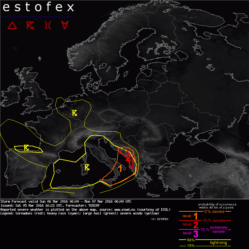
" ... S-Bosnia and Herzegovina, Montenegro, Albania and extreme NW Greece including the Strait of Otranto and the Gulf of Taranto ...
A wavy low-tropospheric front sets up over the CNTRL Adriatic Sea towards Sicily as upstream pressure continues to fall (e.g. a diffuse vortex evolves over the Ligurian Sea as the main trough axis approaches from the W).
Hence, the front will push to the SSE on a slow rate and probably exits the far S-Adriatic Sea not before midnight.Despite frontal intrusions in the past, increasingly confluent low-tropospheric flow over the Ionian Sea causes a deepening of the moist marine layer, which becomes advected to the NE by a 15-20 m/s LLJ. 0-1 km average mixing ratios exceed 10 g/kg and placed beneath 7-8 K/km mid-level lapse rates, 500-900 J/kg MLCAPE is forecast. CIN weakens to the north as 850 hPa temperatures decrease and hence a moist/unstable inflow persists during the forecast, pointing towads the S-Adriatic Sea.
Right entrance of a 50 m/s 300 hPa jet and upper-level divergence will be placed over the area of interest until the night and wave b)
offers adequate deep lift for repeatedly developing deep convection. Predominant CI will be along SE-ward sagging front, but with approaching synoptic-scale lift, enhanced CI is also expected further to the south (e.g. far N-Ionian Sea), where the unstable air mass becomes more or less uncapped.
DLS of 25-35 m/s is more than enough for organized DMC and this also applies for the 0-3 km shear (15-20 m/s). Quite unidirectional 500-700 hPa flow blows near parallel to the front with stronger ageostrophic flow below 850 hPa along the front itself.
Excessive rain will be the main hazard due to repeated thunderstorm development offshore/along the coast. Latest model data keeps region of CI offshore which limits confidence in widespread excessive rainfall reports in the area of interest. However, MUCAPE plume extends well inland, so even onshore, thunderstorms are forecast, which could locally increase the rainfall amounts.
Upslope flow will also increase the rainfall amounts onshore.Fow now we issued a small level 2 area, where MCS remains quasi-stationary for a couple of hours, before gradually shifting to the SE.W/SW Albania and extreme NW Greece can expect all kind of hazards with the SE-ward dropping MCS. A tornado/severe wind gust risk will be confined to the coastal areas and excessive rain extends more inland. Given MUCAPE of 500 J/kg well inland with 30 m/s DLS, large hail can't be ruled out well inland over Albania during the night. We also added W-Albania to the level 2 due to the enhanced supercell risk as the MCS approaches from the NW.
Beside the rainfall risk, any discrete cell will be capable of producing large hail, a few tornadoes and strong to severe wind gusts. In case a V-shaped MCS builds to the SW all the way to SE-Italy, an enhanced tornado/large hail risk may extend that far to the SW.
More isolated CI occurs towards Sicily but DLS in excess of 35 m/s and 500-1000 J/kg MLCAPE point to a supercell risk with any longer-lived thunderstorm. Large hail is forcast and even an isolated very large hail event can't be ruled out...next to an isolated tornado and severe wind gust risk. We therefore expanded the level 1 all the way to Sicily. We have to keep a close eye on degree of CI, as more widespread initiation is possible ... divergent model signals precluded an upgrade for now. "

